Tagged: Jamestown Island

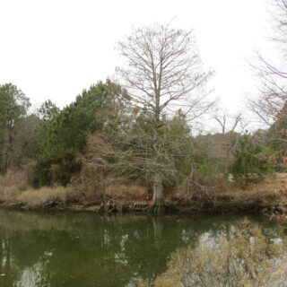
Bald Cypress at Glebe Gut

  This photo, used for our late January 2025 webpage header, was taken along the National Colonial Parkway at Glebe Gut.  It features a bald cypress tree and other native vegetation. Glebe Gut is a narrow, tidal channel that flows under the Colonial Parkway, between College Creek and Mill Creek, near Jamestown Island.  The waterway itself forms the western boundary of a 100-acre tract of land known as the Glebe Land, set aside after 1619 for the use and support...

Summer Wildflowers on Jamestown Island

 May, 1607 Jamestown Island was uninhabited and covered in native vegetation in May of 1607 when the first English settlers chose to establish their colony on a small peninsula in the Powhatan River, now the James River.  That peninsula, along with most of the shoreline of the lower river, was under the control of the Powhatan Chiefdom, a confederation of thirty tribes by that time, based to the north at Werowocomoco, in what is now Gloucester County.  This chiefdom of...